Suggestions you might like to consider in your response might include extracts from the notes below provided for that purpose:
1. INTRODUCTION
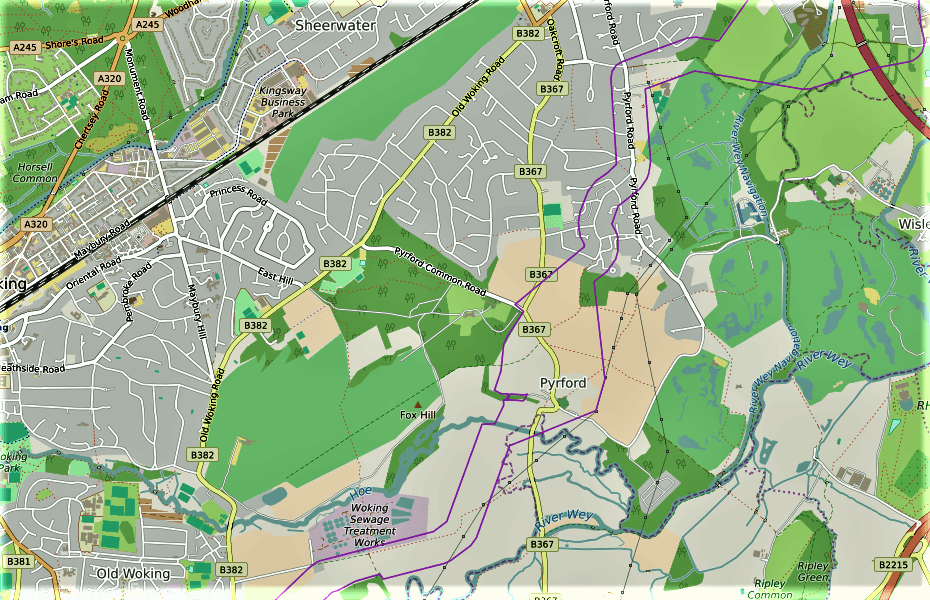
The east and west boundaries of corridor M as they traverse Pyrford are shown by the mauve lines in the illustration above.
Based on community reaction to the ESSO Pipeline proposals the Forum will oppose routing the new pipeline through Pyrford in corridor M/Q. The main grounds for this objection will be based on the potential impact of the pipeline on local:
- Landscape and ecology
- Heritage
- Built environment.
Please note that the same corridor is used for options M and Q through Pyrford and that for simplicity these notes will refer to M but the same comments apply to corridor Q.
Pipelines can be engineered in almost any conditions and the status of the ESSO SLP Project as a nationally strategic project means that engineering costs will not be a major priority for ESSO at this time. Therefore the gist of our argument will be:
why spend time and effort relocating the pipeline in corridor M when a full set of planning precedents exist for the old pipeline and relationships are already well established with landowners and the public in corridor J.
Against this backdrop important points to note for your representation include the following:
2. LANDSCAPE AND ECOLOGY
Floodplain – Corridor M approaches Pyrford across the floodplain from Old Woking, between Woking Palace and the sewage works in Carters Lane, to the foot of Pyrford Escarpment below St Nicholas Church. This floodplain, to the south of Old Woking, is strategic to the flood management plan for the whole of Woking Borough. The floodplain drains into the Hoe Stream and the River Wey and is thereby connected to the floodplain east of Pyrford Road in our area. Both areas are key parts of the Thames Basin flood management plan representing strategic flood holding areas.
Corridor M requires the pipeline to cross many critical drains/ditches that direct water away from the floodplain and into the Hoe Stream and the River Wey. These flood defences will require complete protection from the pipeline crossing under or over them. Any damage to the floodplain caused by this will impact not just Pyrford but the whole of Woking. If the risk of damage to the floodplain is high and the pipeline can’t be re-directed then the floodplain would need to be re-engineered over a very wide area to drain south away from the Hoe Stream. The cost of floodplain reengineering on the scale required would be very high.
Pyrford Escarpment – Pyrford Escarpment is officially designated Rising Land of Landscape Importance and is a very popular recreation area for not only Pyrford residents but a great many others from all parts of Woking Borough. It represents the most scenic part of Pyrford and offers unique views of Newark Priory set in the water meadows of the floodplain directly in front of the Escarpment and beyond to the North Downs.
Ancient Woodland – The western boundary of corridor M intersects The Hanger. The Hanger is officially designated ancient woodland and any damage to the area would be irreparable. It would be a great loss to the community of Pyrford and the character of the Escarpment.
Flora and Fauna – Our area includes a number of nationally important habitats such as wet meadows and ancient woodland which enable the area to support a wide variety of different species of animals and plants. The area supports nationally protected species such as badgers, bats and the Great Crested Newt.
Several Sites of Nature Conservation Importance, a local designation to recognize the wildlife value of a site, are found in the Pyrford Neighbourhood Area and the proposed pipeline through corridor M runs close by.
The sites include Roundbridge Farm SNCI (Grid Reference TQ036576), Pyrford Common SNCI (Grid Ref. TQ030590), Warren Farm Wood and Riverside SNCI (Grid Ref. TQ046575), Wheelers Meadow (south) SNCI (Grid Ref. TQ043579), Wheelers Fields SNCI (Grid Ref. TQ042581), River Wey SNCI (including Pyrford Place Lake TQ051583) and Hoe Stream SNCI (Grid Ref. SU967545 –TQ039581).
Footpaths and Bridleways – The floodplain and the escarpment are criss-crossed by many footpaths and bridleways that are constantly used by walkers in the area; during the week as well as at weekends. Any loss or damage to such amenities due to laying the pipeline in the area would impact a great many people across the whole of Woking and severely impair recreational areas available to the borough.
3. HERITAGE
There are 2 conservation areas and 40 listed buildings in Pyrford – click here for details. Corridor M encompasses the whole of one conservation area, a 1/3 of the other and 24/40 listed buildings on it’s journey across the village. The pipeline cannot be allowed to impact more than 50% of the heritage in a new area when such issues were presumably addressed, for the existing pipeline in corridor J, 50 years ago.
In more detail corridor M threatens:
2*Conservation Areas – Arriving at the foot of Pyrford Escarpment, corridor M completely envelopes the Pyrford Conservation area covering the 12th Century church and graveyard and adjacent buildings of considerable importance. It is hard to see how the pipeline could pass west of St Nicholas Church without causing damage to The Hanger ancient woodland, the church itself, the Old Vicarage, or disturb the curtilage defined to protect the setting of these heritage assets.
On the eastern side of the corridor the modern graveyard would need to be negotiated via a longer detour round the nose of the escarpment.
Further north towards the modern part of Pyrford, corridor M cuts through the lower half of the second conservation area – Aviary Road Conservation Area.
Grade I 12th c St Nicholas Church. – The church itself has seen regular worship for the last 870 years and is one of the oldest in Surrey, built around 1140. It is special in that it stands as a complete building from a single period in time and is picture post card typical of a small rural English church. Contributing to its’ great charm are the nearby views of Newark Priory, the floodplain with the River Wey behind and the North Downs in the distance.
9 * Grade II Listed Buildings – The following table lists the 9 GII listed building located within corridor M:
| LOCATION | DESCRIPTION | CLASS |
| Boltons Lane | Bluegate & Weem Cottage | GII |
| Church Hill | Church Farmhouse | GII |
| Church Hill | Barn – NW of Church Farmhouse | GII |
| Church Hill | Lady Place Cottage | GII |
| Church Hill | Stone Farm | GII |
| Pyrford Road | Barn – 90yds South of Lees Farmhouse | GII |
| Pyrford Road | The Old House | GII |
| Warren Lane | Wheelers Farm | GII |
| Warren Lane | Wheelers Farm Barn | GII |
Included in this group are three properties where the owners have invested a great deal of time and effort conserving the heritage they are living in. In addition, a major restoration project is under way just outside corridor M in Pyrford Court. The park and gardens are Grade II listed but an enormous amount of work has been done to restore the house and regenerate the garden and surrounding park and return things to their things to how they were in 1920’s when property was owned by the Guiness family. At that time the house occupied a prominent position on Pyrford Escarpment and the This is nonetheless Grade II listed house and garden project is broadly reinstating the house and the grounds it is set in, to much more as they were in the 1920’s when the house was owned by the Guinness family.
These 4 projects demonstrate the commitment of local people to respect and look after the heritage assets of the area and their determination to see very significant improvements.
In addition to the heritage assets listed above there is a hay barn and a cart barn that also lie within corridor M, are very old and are obvious candidates to be graded in any heritage appraisal of the area.
10* Buildings of Architectural Significance – see table below.
| LOCATION | DESCRIPTION | CLASS |
| Church Hill | 1 & 2 Lady Place Farm Cottages | AH |
| Pyrford Road | 1 – 7 Providence Place | AH |
| Pyrford Road | Thorley Cottage | AH |
These three listings cover 10 homes and reinforce the importance of Pyrford’s heritage reflecting a rich and varied set of assets.
4*Buildings of Townscape Merit – Listed locally, 4 homes of this type lie within corridor M
| LOCATION | DESCRIPTION | CLASS |
| Church Hill | The Vicarage | TM |
| Pyrford Road | Lees Cottages (1 – 3) | TM |
4. BUILT ENVIRONMENT
Homes – After passing through 2 conservation areas and including 24 listed assets within it’s boundaries corridor M then tracks along Bolton’s Lane and Pyrford Road. 13 of the listed assets referred to above are included in this section of the corridor and approximately 300 homes in total lie within it and ESSO have alarmed many people with correspondence seeking confirmation of land ownership giving rise to alarm and thoughts that compulsory purchase orders might come next.
This is thoughtless and reprehensible when the route for the pipeline is still to be decided but materially it will impact residents living adjacent to where the pipeline might go blighting the value of property for some time to come who are contemplating a move for whatever reason.
Such issues will be significantly less if ESSO choose to route the new pipeline next to the old, in corridor J because land issues were largely settled 50 years ago.
Roads – From the definition of corridor M it would seem that ESSO would choose to lay the pipeline actually in Bolton’s Lane and Pyrford Road. This would minimise disruption to individual homes but play havoc with traffic.
These roads bound Pyrford and are exceptional busy for access to motorways, mainline rail stations for commuters and school children attending Pyrford C of E Primary School.
Coldharbour Road is the other main artery in Pyrford and infamous for congestion in the morning and evening rush hours for commuters and school children. Constricting the main alternative routes to Coldharbour Rd by denying or constricting traffic flow on both Bolton’s Lane and Pyrford Road will exacerbate this situation and put primary school children in greater traffic safety danger.
Utilities – When MacFarlanes laid the new 33kv electricity grid cable down Pyrford Road last year it took significantly longer than expected because of other, gas, water, electricity and fibreoptic cable services that were largely unmapped but all using the same stretch of road.
The location of utility supply in Pyrford has been a source of concern for many years because it seems no reliable location maps are available.
Using these roads would therefore seem a high risk strategy that could impact a great many more residents than in the 300 homes included by the definition of corridor M. Especially when the route runs beside the T golf course that could provide a shortcut to Dodds bridge where the pipeline eventually leaves Pyrford.


Previous Comments